LITHOGRAPHIC PRINT OF THE NEW USDA PLANT HARDINESS ZONE MAP
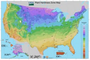
The Plant Hardiness Zone Map is a map with designations that represent the average extreme minimum temperatures in your area of the United States. The lowest temperature during the winter is a crucial factor to the survival of plants. This is valuable knowledge, with it you can tell if a plant will be able to survive the winter where you live.
Posters of the earlier 1990 map were sold by the Government Printing Office, which does not plan to print and sell posters of the new map, even though it shows significant changes from the last one.
We think it’s a beautiful map, and can’t be fully appreciated on a screen. It deserves to be seen at full size: A big, 40 x 60 inch print of the beautiful, new USDA Plant Hardiness Zone Map, printed with genuine offset lithography.
Williams & Heintz originally printed the USDA Plant Hardiness Zone Map map as a Kickstarter Project in 2013. You cam learn more about the project here.
You may purchase the big, 40” x 60” print of the beautiful, new USDA Plant Hardiness Zone Map Genuine Offset Lithography directly from Williams & Heintz. The map is available with or without lamination. Prices include shipping.